Maps of the Cannell Trail
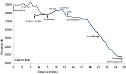
 2D map of the Cannell Trail. The dotted blue line at the top is the extension that starts at Sherman Pass and ends at Big Meadow, adding 8 miles of singletrack to the ride. The dotted black line is the short ride on the pavement back to the MRA campground and showers.  Profile of the Cannell Trail. The regular ride is 20.7 miles, but the extension at the beginning from Sherman Pass (shown in brown) makes it 25.5 miles and adds about 1000 feet of climbing. Here is the shuttle company. Our van broke down, stranding us for an hour plus by the side of the river; but if that doesn't happen to you it's a good way to go. I cannot say enough GOOD THINGS about the riding on Cannell Trail and Just Outstanding. Ridiculous amounts of ripping fast f-u-n. Anyone considering a trip to the area should do it. Next fall. It's fecking hot there and getting hotter. | |


No comments:
Post a Comment